Covered Bridges
Dartmouth covered bridges are a living example of engineering history
16 listings
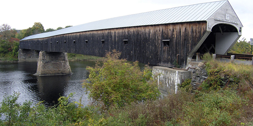
Windsor, VT
Cornish-Windsor Bridge
Crosses the Connecticut River between Bridge Street, Windsor, VT, and NH Route 12A, Cornish, NHLocation: 0.3 miles south of the junction of Route 44 at Windsor on US5 then 0.2 miles left.
Probably the most prominent of all of Vermont’s and New Hampshire’s covered bridges, the Cornish-Windsor Bridge, built in 1866, is the longest wooden covered bridge in the United States and the longest two-span covered bridge in the world. At 450 feet long, the bridge consists of two spans supported by Town lattice trusses. The pier stands nearly under the midpoint of the bridge: the two clear spans measure 204.6 feet and 203.7 feet. The bridge is listed on the National Register of Historic Places. Three earlier bridges at this spot, the first of them built in 1796, were destroyed by floods. The bridge, which originally cost $9,000 to build, was rebuilt in 1989 at a cost of $4,450,000 and reopened on December 8, 1989.
Langdone, NH
Prentiss / Drewsville Bridge
Old Cheshire TurnpikeLocation: One-half mile south of N.H. Route 12A
Built in 1791, this bridge, the smallest covered bridge in New Hampshire, carries the Old Cheshire Turnpike over Great Brook in Langdon. It is the third bridge on this site. It was bypassed in 1954 and now serves foot traffic only. Town lattice truss with light arches; 34 feet long.
Lebanon, NH
Packard Hill Bridge
Riverside DriveLocation: On Riverside Drive in Lebanon
Between 1780 and 1790 an open timber bridge was constructed at this location for Ichabod Packard. In 1878, the open timber bridge was replaced by a Howe truss covered bridge. It was replaced in 1952 with a Bailey Bridge. The Bailey bridge was replaced in 1991 by the current bridge, which carries Riverside Drive across the Mascoma River. It was constructed in a manner which replicates the traditional style of covered bridges. Howe truss; 76 feet long.
Warner, NH
Dalton / Joppa Road Bridge
Joppa RoadLocation: South of N.H. Route 103 on Joppa Road
Built in 1853, this bridge carries Joppa Road across the Warner River. This is one of the oldest standing covered bridges in use today. It is also known as the Joppa Road Bridge. The bridge was rebuilt in 1963-1964. Long truss with an auxiliary Queenpost system; 76 feet long.
Plainfield, NH
Meriden / Mill Bridge
Colby Hill RoadLocation: 1 mile northwest of Route 120 in Meriden Village
This bridge, built in 1880, carries Colby Hill Road over Blood Brook. Two-span multiple kingpost truss with a total length of 80 feet. Large parking area available on right side of Colby Hill Road before crossing the bridge.
Cornish, NH
Blow Me Down Bridge
Mill RoadLocation: South of Route 12A, 1.5 miles southwest of Plainfield Village
The Blow Me Down Bridge, built in 1877, carries Mill Road over Blow Me Down Brook. Multi-kingpost truss; 85 feet long. Parking available in pull off before crossing the bridge.
Cornish, NH
Dingleton Bridge
Root Hill RoadLocation: 1.0 mile east of Route 12A on Root Hill Road
This bridge, built in 1882, carries Root Hill Road over Mill Brook. One-span multiple kingpost truss with a total length of 77 feet. Parking available on left side of Root Hill Road after crossing the bridge.
Newport, NH
Wright’s Bridge
Location: Two miles south of N.H. Route 103 and one-half mile west of Chandler Station in Newport
This bridge, on the Concord and Claremont Railroad line spanning the Sugar River, was built in 1906 by the Boston and Maine Railroad. It replaced a wooden bridge built by the Sugar River Railroad in 1871 and 1872. The Concord and Claremont Railroad was well known for its use of the double Town/Pratt lattice truss. In 1915, there were 15 such bridges on the rail line.
Lyme, NH
Edgell Bridge
River RoadLocation: One mile south of N.H. Route 10, two miles south of Orford Village
Built in 1885, this bridge carries River Road across Clay Brook. The bridge was assembled on the town common and moved by oxcart to the planned location. In 1936, it washed off its northern abutment. It was moved back, and tied down with cables. Town lattice truss; 132 feet long.
Andover, NH
Cilleyville / Bog Bridge
Location: At the junction of N.H. Route 11 and N.H. Route 4A
Built in 1887, this bridge spans Pleasant Brook. It was bypassed in 1959 and restricted to foot traffic. The bridge was the model for murals of typical New Hampshire scenes which were once located in the State House in Concord. Town lattice truss; 53 feet long.
Newport, NH
Pier Bridge
Location: East of Chandler Station and west of N.H. Route 103 on the Concord and Claremont Railroad line spanning the Sugar River.
The current bridge was built in 1907 by the Boston and Maine Railroad to replace a wood lattice bridge constructed in 1871-1872 by the Sugar River Railroad. The double Town/Pratt lattice trusses with laminated arches were long favored on the branch lines of the Boston & Maine Railroad. In 1900 at least 100 of this type of truss were in use on the Boston & Maine system. Double Town-Pratt lattice truss; 216 feet long.
Landgon, NH
McDermott / Cold River Bridge
Location: North of N.H. Route 123A, two miles north of Alstead Village
Built in 1869, this bridge is the fourth on this site. Previous bridges were built in 1790, 1814, and 1840. A modern bridge which was built downstream in 1964 and the covered bridge was closed to vehicular traffic and retained for historic reasons. Town lattice truss with light arches; 81 feet long.
Bradford, NH
Bement Bridge
Bradford Center RoadLocation: One quarter mile north of the intersection of N.H. Routes 103 and 114
Built in 1854, this bridge carries Bradford Center Road across the west branch of the Warner River. Tradition has it that Colonel Stephen H. Long, a Hopkinton native and a member of the U.S. Army Topographical Engineers, built the bridge. While working for the Baltimore and Ohio Railroad, Long developed a plan for a new covered bridge truss that became nationally known as the Long truss. Long patented his design in 1830. Long truss; 60 feet long.
Warner, NH
Waterloo Bridge
New Market RoadLocation: South of N.H. Route 103, two miles west of Warner Village
Built in 1840, this bridge carries New Market Road across the Warner River. The structure was completely rebuilt in 1857 and a second time in 1970, and it was rehabilitated in 1987 at a cost of $3,000. Town lattice truss; 76 feet long.
Cornish, NH
Blacksmith Bridge
Town House RoadLocation: 2 miles east of Route 12A
This bridge, built in 1881, carries a foot path over the Mill Brook in the town of Cornish. It is just a few miles south of the Cornish-Windsor Bridge, which crosses the Connecticut River between Vermont and New Hampshire. The name was derived from a nearby blacksmith shop. One-span multi-kingpost truss; 91 feet long. Parking available along Town House Road for two or three cars.
Andover, NH
Keniston Bridge
Lorden RoadLocation: South of U.S. Route 4, one mile west of Andover Village
Built in 1882, this bridge carries Lorden Road over the Blackwater River. The bridge's name came from a prominent family that lived for many years in one of the old homesteads in town. The bridge has been damaged only once, in 1972, when ice tore off several planks. The bridge was rehabilitated by the town in 1981. Town lattice truss; 64 feet long.