Covered Bridges
Covered bridges are a favorite among New England visitors and photographers, from kids to senior citizens. The affection that many visitors acquire for New England’s covered bridges often begins behind a camera. These small gems of 19th-century ingenuity are fun to photograph as weather and the changing seasons costume them with icicles, snow caps, and brilliant fall foliage.
Get the full flavor of a covered bridge tour by tucking away for a night or two at a historic hotel or inn or a cozy cabin or cottage.
45 listings
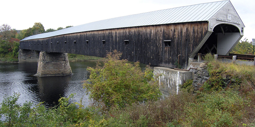
Windsor, VT
Cornish-Windsor Bridge
Crosses the Connecticut River between Bridge Street, Windsor, VT, and NH Route 12A, Cornish, NHLocation: 0.3 miles south of the junction of Route 44 at Windsor on US5 then 0.2 miles left.
Probably the most prominent of all of Vermont’s and New Hampshire’s covered bridges, the Cornish-Windsor Bridge, built in 1866, is the longest wooden covered bridge in the United States and the longest two-span covered bridge in the world. At 450 feet long, the bridge consists of two spans supported by Town lattice trusses. The pier stands nearly under the midpoint of the bridge: the two clear spans measure 204.6 feet and 203.7 feet. The bridge is listed on the National Register of Historic Places. Three earlier bridges at this spot, the first of them built in 1796, were destroyed by floods. The bridge, which originally cost $9,000 to build, was rebuilt in 1989 at a cost of $4,450,000 and reopened on December 8, 1989.
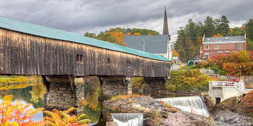
Bath, NH
Bath Bridge
Pettyboro RoadLocation: West of U.S. Route 302 over the Ammonoosuc River
Built in 1832, the current structure is the fifth bridge to stand on this site. The first was constructed in 1794, demolished by a flood, and replaced in 1806. The second and third bridges were also destroyed by floods and replaced in 1820 and again in 1824. The fourth bridge was destroyed by fire in late 1830. Rebuilding efforts began in March 1831. Burr truss with supplemental arches; 374 feet long.
Lebanon, NH
Packard Hill Bridge
Riverside DriveLocation: On Riverside Drive in Lebanon
Between 1780 and 1790 an open timber bridge was constructed at this location for Ichabod Packard. In 1878, the open timber bridge was replaced by a Howe truss covered bridge. It was replaced in 1952 with a Bailey Bridge. The Bailey bridge was replaced in 1991 by the current bridge, which carries Riverside Drive across the Mascoma River. It was constructed in a manner which replicates the traditional style of covered bridges. Howe truss; 76 feet long.
Ashland, NH
Squam River Bridge
River StreetLocation: On River Street, spanning the Squam River
This covered bridge, built in 1990, replaces a steel and concrete bridge that was condemned by the state. After the condemnation, the state proposed a two-lane steel bridge for this site. The citizens of Ashland, however, voted to fund one-lane covered bridge. The bridge was constructed by Milton Graton and Sons in the traditional style and was dedicated on July 1, 1990. Town lattice truss; 61 feet long.
North Woodstock, NH
Clark’s Bridge
Location: East of U.S. Route 3 in Clark's Trading Post on Clark's Short Steam Railroad
Clark's Bridge was originally built in Barre, Vermont, in 1904 as a part of the Barre Railroad, to span the Winooski River. In 1960 the railroad line and the covered bridge were abandoned. The bridge was dismantled in East Montpelier and taken to its present site. The bridge was reassembled on dry land next to the Pemigewasset River. It was positioned over the river in 1965 and is still used as a part of Clark's Short Steam Railroad. It appears to be the only Howe railroad bridge left in the world. Howe Truss; 116 feet long.
Henniker, NH
Henniker Bridge
Location: South of N.H. Route 9 in Henniker Village spanning the Contoocook River
This bridge, which crosses the Contoocook river, was built by Milton Graton and his son Arnold in 1972 using traditional methods. The bridge serves New England College and the community of Henniker as a footbridge. Town lattice truss; 136 feet long; limited to pedestrian and maintenance vehicle use.
Newport, NH
Wright’s Bridge
Location: Two miles south of N.H. Route 103 and one-half mile west of Chandler Station in Newport
This bridge, on the Concord and Claremont Railroad line spanning the Sugar River, was built in 1906 by the Boston and Maine Railroad. It replaced a wooden bridge built by the Sugar River Railroad in 1871 and 1872. The Concord and Claremont Railroad was well known for its use of the double Town/Pratt lattice truss. In 1915, there were 15 such bridges on the rail line.
Newport, NH
Pier Bridge
Location: East of Chandler Station and west of N.H. Route 103 on the Concord and Claremont Railroad line spanning the Sugar River.
The current bridge was built in 1907 by the Boston and Maine Railroad to replace a wood lattice bridge constructed in 1871-1872 by the Sugar River Railroad. The double Town/Pratt lattice trusses with laminated arches were long favored on the branch lines of the Boston & Maine Railroad. In 1900 at least 100 of this type of truss were in use on the Boston & Maine system. Double Town-Pratt lattice truss; 216 feet long.
Ossipee, NH
Whittier Bridge
Location: West of N.H. Route 16 at West Ossipee Village on old N.H. Route 125
The first covered bridge on this site, crossing the Bearcamp River, was built in 1820 and rebuilt in 1832. The current bridge dates from the 1870s. A restoration began in November 1982 by Milton Graton and Sons and was completed in August 1983. The sides of the Whittier Bridge were opened as part of the restoration. Paddleford truss with added arches; 132 feet long. The bridge is closed to vehicle traffic.
Sandwich, NH
Durgin Bridge
Durgin RoadLocation: One and one-half miles north of N.H. Route 113, east of North Sandwich Village
This bridge, built in 1869, carries Durgin Road across the Cold River. The first bridge at this site was built to replace a fordslightly upstream. The current bridge is the fourth one on this site; the others was washed away in 1844, 1865, and 1869. The bridge was also a link in the underground slave railroad from Sandwich to North Conway. Milton Graton and his son Arnold repaired and strengthened the structure in 1967-1968 and it was rehabilitated in 1983. Paddleford truss with added arches; 96 feet long.
Campton, NH
Bump Bridge
Bump RoadLocation: One mile east of N.H. Route 175 at Campton Hollow
The original Queenpost structure at this site was built in 1877. The bridge carries Bump Road across the Beebe River. At one time the bridge was known as the Webber Bridge. The current structure was built by Arnold Graton in 1972. Queenpost truss; 68 feet long.
Campton, NH
Turkey Jim’s Bridge
Old Stephan's RoadLocation: The bridge can be reached by driving into the campground just east of U.S. Route 3 and north of N.H. Route 49.
The original covered bridge on this site, which carries Old Stephan’s Road across West Branch Brook, was built in 1874. The bridge's name originates from farmer, Jim Cummings, whose property was known as Turkey Jim's Turkey Farm. The bridge was replaced in 1958 by Milton Graton. In 1964, the bridge washed downstream, was retrieved, and set back on its abutments. Open only to pedestrian and snowmobile traffic. Queenpost truss; 60 feet long.
Campton, NH
Blair Bridge
Blair RoadLocation: East of U.S. Route 3, two miles north of Livermore Falls
The first bridge at this location, which carries Blair Road across the Pemigewasset River, was built in 1829. That bridge was burned down by a man named Lem Parker who claimed that God told him to do it. The current bridge was built in 1869 after a doctor trying to ford the river on horseback found the current too strong. The horse drowned, but the doctor was saved. The town voted to build a bridge immediately. It was rebuilt by Milton Graton and his son Arnold in 1977. Long truss with arches; 292 feet long.
West Hopkinton, NH
Rowell’s Bridge
Clement Hill RoadLocation: North of N.H. Route 127 on Clement Road
Built in 1853, the bridge carries Clement Hill Road across the Contoocook River. A short time after it was built, a herd of cattle moved the bridge off its abutments. The structure was brought back and secured. The structure was rebuilt by the state in 1965. The Antiquarian Society in Hopkinton has a demonstration model of a Long truss on display. Long truss with Burr arches; 164 feet long.
Hopkinton, NH
Railroad Bridge
Location: East of N.H. Route 103 in Contoocook Village
Built in 1850 and reconstructed in 1889, this bridge carries the Concord and Claremont Railroad line across the Contoocook River. It was built when the Concord and Claremont Railroad laid track from Concord to Bradford, N.H. The bridge washed off its abutments in 1936 when the Contoocook River flooded and again in 1938 from a hurricane. After the flood water receded, the bridge was drawn back to its location and restored. Double Town-Pratt lattice truss; 140 feet long.
Warner, NH
Dalton / Joppa Road Bridge
Joppa RoadLocation: South of N.H. Route 103 on Joppa Road
Built in 1853, this bridge carries Joppa Road across the Warner River. This is one of the oldest standing covered bridges in use today. It is also known as the Joppa Road Bridge. The bridge was rebuilt in 1963-1964. Long truss with an auxiliary Queenpost system; 76 feet long.
Warner, NH
Waterloo Bridge
New Market RoadLocation: South of N.H. Route 103, two miles west of Warner Village
Built in 1840, this bridge carries New Market Road across the Warner River. The structure was completely rebuilt in 1857 and a second time in 1970, and it was rehabilitated in 1987 at a cost of $3,000. Town lattice truss; 76 feet long.
Bradford, NH
Bement Bridge
Bradford Center RoadLocation: One quarter mile north of the intersection of N.H. Routes 103 and 114
Built in 1854, this bridge carries Bradford Center Road across the west branch of the Warner River. Tradition has it that Colonel Stephen H. Long, a Hopkinton native and a member of the U.S. Army Topographical Engineers, built the bridge. While working for the Baltimore and Ohio Railroad, Long developed a plan for a new covered bridge truss that became nationally known as the Long truss. Long patented his design in 1830. Long truss; 60 feet long.
Andover, NH
Keniston Bridge
Lorden RoadLocation: South of U.S. Route 4, one mile west of Andover Village
Built in 1882, this bridge carries Lorden Road over the Blackwater River. The bridge's name came from a prominent family that lived for many years in one of the old homesteads in town. The bridge has been damaged only once, in 1972, when ice tore off several planks. The bridge was rehabilitated by the town in 1981. Town lattice truss; 64 feet long.
Andover, NH
Cilleyville / Bog Bridge
Location: At the junction of N.H. Route 11 and N.H. Route 4A
Built in 1887, this bridge spans Pleasant Brook. It was bypassed in 1959 and restricted to foot traffic. The bridge was the model for murals of typical New Hampshire scenes which were once located in the State House in Concord. Town lattice truss; 53 feet long.
Landgon, NH
McDermott / Cold River Bridge
Location: North of N.H. Route 123A, two miles north of Alstead Village
Built in 1869, this bridge is the fourth on this site. Previous bridges were built in 1790, 1814, and 1840. A modern bridge which was built downstream in 1964 and the covered bridge was closed to vehicular traffic and retained for historic reasons. Town lattice truss with light arches; 81 feet long.
Langdone, NH
Prentiss / Drewsville Bridge
Old Cheshire TurnpikeLocation: One-half mile south of N.H. Route 12A
Built in 1791, this bridge, the smallest covered bridge in New Hampshire, carries the Old Cheshire Turnpike over Great Brook in Langdon. It is the third bridge on this site. It was bypassed in 1954 and now serves foot traffic only. Town lattice truss with light arches; 34 feet long.
Lyme, NH
Edgell Bridge
River RoadLocation: One mile south of N.H. Route 10, two miles south of Orford Village
Built in 1885, this bridge carries River Road across Clay Brook. The bridge was assembled on the town common and moved by oxcart to the planned location. In 1936, it washed off its northern abutment. It was moved back, and tied down with cables. Town lattice truss; 132 feet long.
Bath and Haverhill, NH
Bath-Haverhill Bridge
route 135Location: One-quarter mile north of U.S. Route 302 in Woodsville Village
Built in 1829, this bridge carries Route 135 across the Ammonoosuc River. It is the oldest covered bridge still in use in New Hampshire and the first and only bridge at this site. Town lattice truss with arches; 256 feet long.
Bath, NH
Swiftwater Bridge
Valley RoadLocation: North of N.H. Route 112 over the Wild Ammonoosuc River
Built in 1849, this bridge carries Valley Road across the Wild Ammonoosuc River. This bridge is the fourth to cross the Wild Ammonoosuc River at this site. The first was built in 1810, carried away in 1818 by a flood and replaced in the same year. That bridge was destroyed by a flood in 1828. The third bridge was erected in 1829 and remained at the site until 1849. At that time it was dismantled and replaced by the current bridge. This bridge was rebuilt by the state in 1977. Paddleford truss with added arches; 158 feet long.
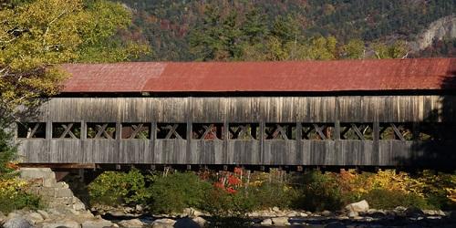
Albany, NH
Albany Bridge
Passaconaway RoadLocation: Just north of the Kancamagus Highway, six miles west of N.H. Route 16
This bridge is located in the White Mountain National Forest, off the Kancamagus Highway. It carries Paccanaway Road over the Swift River just a short distance from the Covered Bridge Campground. The bridge was built in 1858, replacing an earlier bridge, built in 1857, that was destroyed by a wind storm. The U.S. Forest Service modified the structure in 1981-1982, replaced the wooden floor timbers with steel. Paddleford truss with added arches; 120 feet long. Parking available in a White Mountain National Forest parking lot near the bridge.
Winchester, NH
Ashuelot / Village / Village Station Bridge
Bolton RoadLocation: South of N.H. Route 119 in the Upper Village of Ashuelot
This bridge, built in 1864, carries Bolton Road across the Ashuelot River, It is considered one of New Hampshire’s most elaborate covered bridges. The original purpose of the bridge was to transport wood across the river for use by the Ashuelot Railroad. Two-span Town lattice truss; 169 feet long.
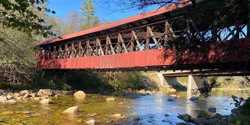
Bartlett (Intervale), NH
Bartlett Covered Bridge and Gift Shop
Near Route 302Location: West on U.S. Route 302, four and one-half miles east of Bartlett Village
This bridge, built in 1857, spans the Saco River. The bridge was abandoned and closed to traffic in 1939, and began to deteriorate. In the 1950s, it was used to store town equipment and snow fencing. In 1966 the bridge was purchased by a private individual who had it repaired and began to operate a gift shop inside the structure. The gift shop remains in business today, under newer owners, from Memorial Day through October. Paddleford truss with added arches; 166 feet long. Limited parking.
Cornish, NH
Blacksmith Bridge
Town House RoadLocation: 2 miles east of Route 12A
This bridge, built in 1881, carries a foot path over the Mill Brook in the town of Cornish. It is just a few miles south of the Cornish-Windsor Bridge, which crosses the Connecticut River between Vermont and New Hampshire. The name was derived from a nearby blacksmith shop. One-span multi-kingpost truss; 91 feet long. Parking available along Town House Road for two or three cars.
Cornish, NH
Blow Me Down Bridge
Mill RoadLocation: South of Route 12A, 1.5 miles southwest of Plainfield Village
The Blow Me Down Bridge, built in 1877, carries Mill Road over Blow Me Down Brook. Multi-kingpost truss; 85 feet long. Parking available in pull off before crossing the bridge.
Swanzey, NH
Carleton Bridge
Carleton RoadLocation: On Route 32, 4.5 miles south of the junction of Route 12 southeast of Keene; then left 0.3 miles
This bridge, built in 1869, carries Carleton Road over the South Branch of the Ashuelot River. According to local tradition, the bridge was built by local barn builders since the truss construction of the bridge is similar to that used in barns. When it was built, a wagon fully loaded with hay was used as a standard for the height and width of the opening.
Franklin, NH
Sulphite Bridge
Location: One-half mile east of Franklin Falls and south of U.S. Route 3
This bridge carries the Boston and Maine Railroad line across the Winnipesaukee River. This unusual bridge, built in 1896, is the only deck-covered railroad bridge left in the United States. It was named Sulphite because of the large amounts of sulfur transported over the rail lines for use by the giant pulp and paper mills nearby. It is also known as the Upside Down Covered Bridge because the railroad track crosses over the top of the structure rather than running through its center. Service over the line was suspended in 1973. Pratt truss; 1280 feet long.
Lincoln, NH
Sentinel Pine Bridge
Location: in the Flume Gorge, Franconia Notch State Park
This bridge, built in 1939, is located in Franconia Notch State Park and it carries a hiking trail over the Pemigewasset River just a short distance from the Franconia Notch Visitors Center. It is considered a “romantic” structure, meaning that it is an authentic reproduction of a historic covered bridge, but built of materials other than timber, with no truss or arch. The covered portion of the bridge is 60 feet long. This bridge along with the Flume Bridge are all part of some of the natural attractions that make up the area generally known as the Flume.
West Swanzey, NH
West Swanzey / Thompson Bridge
Main Street RoadLocation: East of N.H. Route 10
This bridge, built in 1832, carries Main Street Road over the Ashuelot River. In 1973, when it was posted for a six-ton limit, school buses were not allowed to cross the bridge with students onboard. When a bus full of students came to the bridge, the students would get off the bus, walk across the bridge, and re-board the bus. Closed to vehicle traffic. It is a two-span Town lattice truss with a total length of 136 feet.
Conway, NH
Swift River Bridge
Location: One-half mile north of N.H. Route 16 at Conway Village
The first bridge at this site, crossing the Swift River, was built in 1850. In 1869, it was swept off its abutments by the raging Swift River and it rode downstream into the Saco River, where it crashed into the Saco River bridge. Debris from both bridges was salvaged and used in rebuilding this bridge. In 1974, the bridge was bypassed in favor of a new concrete and steel structure. Paddleford truss with arch; 133 feet long.
Winchester, NH
Coombs Bridge
Old Westport RoadLocation: West of N.H. Route 10, one-half mile southwest of Westport Village
This bridge, built in 1837, carries Old Westport Road across the Ashuelot River. It was named for after its builder and first owner. The bridge was rehabilitated in 1971. One-span Town lattice truss with a total length of 106 feet.
Cornish, NH
Dingleton Bridge
Root Hill RoadLocation: 1.0 mile east of Route 12A on Root Hill Road
This bridge, built in 1882, carries Root Hill Road over Mill Brook. One-span multiple kingpost truss with a total length of 77 feet. Parking available on left side of Root Hill Road after crossing the bridge.
Swanzey, NH
Sawyers Crossing / Cresson Bridge
Sawyers Crossing RoadLocation: One mile north of N.H. Route 32 near the site of an old Indian community
This bridge, built in 1859, carries Sawyers Crossing Road over the Ashuelot River. This structure replaces a much earlier bridge on this location. When the rebuilt bridge was opened, the event was celebrated with an all-night town dance on the bridge, with a four-piece orchestra and a midnight lunch. Town lattice truss with a total length of 159 feet.
Conway, NH
Saco River Bridge
East Side StreetLocation: 0.4 miles north of the junction routes 16 and 153 on east side of road. In Conway Village go north on Washington Street and turn right at the fork; this is East Side Road.
This bridge, built in 1890 by Charles Broughton and his son, Frank, carries East Side Road over the Saco River a short distance north of Conway Center. In 1850s, Jacob Berry and Peter Paddleford built a covered bridge to replace a crudely framed log bridge that had collapsed at this site. The 1850 bridge stood until the Swift River covered bridge crashed into it in 1869 after that bridge was swept from its abutments. The bridge was rebuilt by Allen and Warren of Conway but it was destroyed again by a tannery fire in 1890. The existing structure replaces the one destroyed by the fire. Paddleford truss with added arches; 224 feet long. There is a small parking lot on the northeast side of the bridge.
Jackson, NH
Jackson / Honeymoon Bridge
Main Street at Pinkham Notch RoadLocation: From the intersection of Routes 16 and 16A, travel east on Route 16A
This bridge, built in 1876, carries Main Street (formerly called Village Street) across the Ellis River. Called Honeymoon Bridge because of a longstanding tradition of newly married couples having their photo taken at the bridge. A sidewalk was added in 1930. Paddleford truss with added arches; 121 feet long.
Plainfield, NH
Meriden / Mill Bridge
Colby Hill RoadLocation: 1 mile northwest of Route 120 in Meriden Village
This bridge, built in 1880, carries Colby Hill Road over Blood Brook. Two-span multiple kingpost truss with a total length of 80 feet. Large parking area available on right side of Colby Hill Road before crossing the bridge.
Stark Village, NH
Stark Bridge
North RoadLocation: Northwest of N.H. Route 110 on North Road in Stark Village over the Upper Ammonoosuc River.
The bridge is 134 feet long and it has sidewalks on each side. During the 1890s, high water removed the center pier and the bridge was washed downstream. It was brought back by men and oxen and set on new stone piers. The bridge failed again in the 1940s and in 1954 was rehabilitated. During the 1950s, the people of Stark voted to replace the bridge with a new steel bridge. The outcry from artists was so great that the covered bridge was restored. The bridge is listed on the National Register of Historic Places.
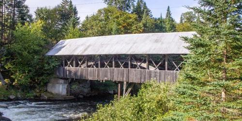
Pittsburg, NH
Pittsburg-Clarksville Covered Bridge (also called the Bacon Road Bridge)
Bacon RoadLocation: South of U.S. Route 3, west of Pittsburg Village on Bacon Road over the Connecticut River
This 88-foot bridge is the northernmost bridge to cross the Connecticut River, on its 400- mile journey south to Long Island Sound. Town records indicate that money was raised to build this bridge back in 1876. The Town of Clarksville was approached by Pittsburg officials "....to see what the town would do about paying the Town of Pittsburg for building two-thirds of the bridge ..." but Clarksville declined to pay Pittsburg anything." This structure is one of seven covered bridges in Pittsburg and one of three that remain standing. It was closed to traffic in 1981.
Pittsburg, NH
Happy Corner Bridge
Hill-Danforth RoadLocation: Six miles north of Pittsburg Village on Hill Road over Perry Stream.
Happy Corner was a bustling neighborhood in the late 1800s. At the Perry Stream crossing there was a sawmill, a starch mill, a store and post office, a barbershop, and the Temperance Hall. The bridge got its name from an elderly gentleman who lived in a house at the crossroads. This gentleman liked to sing and dance, and he owned a Victrola which he played frequently. People congregated at his house generally had a "happy" time singing and dancing. The crossroads got the name Happy Corner. Happy Corner Bridge is one of the oldest covered bridges in northern New Hampshire.
Pittsburg, NH
River Road Bridge
River RoadLocation: Seven miles north of Pittsburg Village on the road to Lake Francis State Park. It spans Perry Stream.
Little is known about this bridge and nothing has been recorded in the town records. The bridge is closed to all but pedestrian traffic.